Modelling of the wind environment and construction of ventilation corridors in high-density cities with CFD and machine learning
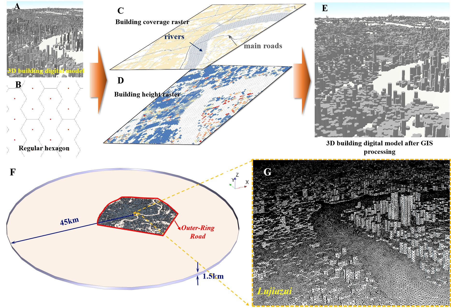
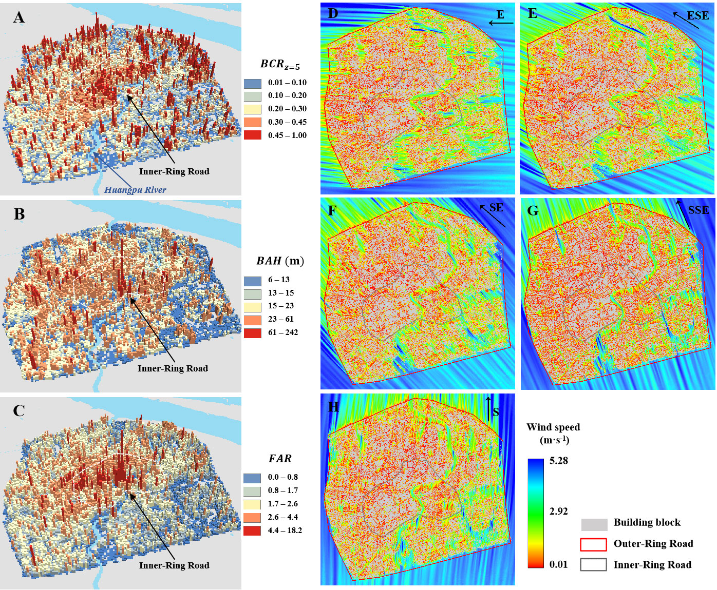
Urban ventilation corridors can enhance ventilation potentials to a certain extent by enhancing peri-urban gas exchange to improve urban environmental problems, while highly heterogeneous urban forms in high-density cities will affect the distribution of urban wind speed and make the estimation of ventilation potential of ventilation corridors unpredictable. In particular, complex building forms not only hinder the efficient quantification of the contribution of urban form to the ventilation potentials of each corridor, but make it challenging to obtain the spatial distribution of threedimensional wind fields under the influence of complex urban forms. Taking the central urban area of Shanghai as an example, this paper used computational fluid dynamics (CFD) method to simulate the high-resolution three-dimensional wind field in the central urban area, and basically used machine learning method to construct urban ventilation corridors with better ventilation potentials, in order to provide scientific reference for the planning and environmental improvement of ventilation corridors in high-density cities. Specific results and conclusions are as follows: 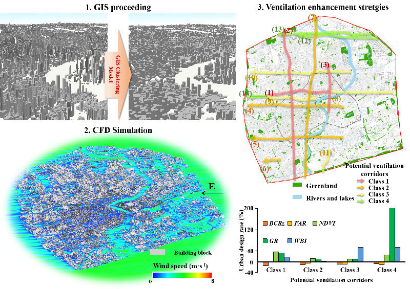 On one hand, this paper combined CFD and GIS methods to simulate high-spatial resolution three-dimensional wind fields under the influence of different inlet wind speeds and directions so as to explore the quantitative relationship between urban form and ventilation potentials: (1) A GIS building aggregation model was developed to simplify a large number of three-dimensional building entities into three-dimensional building block entities, which has reduced the cost of numerical simulation; (2) The RNG k−ε turbulence model based on RANS method was used to simulate the threedimensional wind field with 30m horizontal resolution and 10m vertical resolution under the influence of different inlet wind speeds and directions. (3) The influence of building form on horizontal and vertical wind fields was analyzed, and the quantitative relationship between urban form and ventilation potentials at different vertical heights was analyzed. We found that more complex building forms in the central area could reduce the ventilation potential of the area, and the ventilation potential was greater when the background wind direction ws E and S. Larger building coverage ratio (𝐵𝐶𝑅𝑧) could reduce mean wind speed (𝑈𝑚𝑒𝑎𝑛) and maximum wind speed (𝑈𝑚𝑎𝑥) below the height of 20m near the ground while larger building volume ratio (𝐹𝐴𝑅) would educe 𝑈𝑚𝑒𝑎𝑛 below 20m. Enhansing normalized vegetation index (𝑁𝐷𝑉𝐼), green area ratio (𝐺𝑅) and water body iindex (𝑊𝐵𝐼) would increase the ventilation potentials near the ground. The weakening of 𝑈𝑚𝑒𝑎𝑛 and 𝑈𝑚𝑎𝑥 has a significant impact on alleviating urban heat islands.